


Utah Owner app for iPhone and iPad
Developer: Mike Duncan
First release : 04 Feb 2015
App size: 11.81 Mb
This app provides very detailed maps of property owners in Utah displayed over Apple road and satellite maps and your GPS position. Neither Wi-Fi nor phone service is required to use it in the field. Perimeters and interior in-holdings of more than 6000 parcels ("features" in GIS parlance) can be shown.
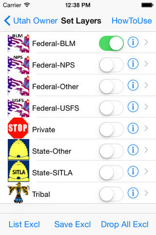
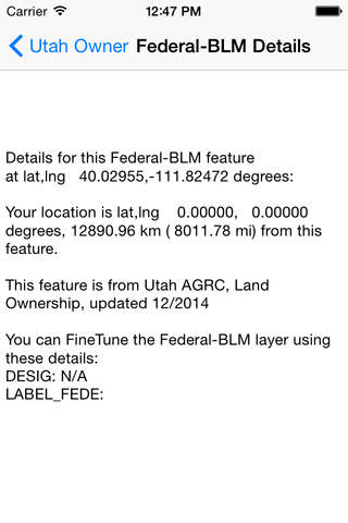
Property owners are divided into eight categories (Federal National Parks, Federal Bureau of Land Management, Federal Forest Service, other Federal owners, State Institutional Trust Lands, other State owners, Tribal owners, and Private) , any combination of which may be "layered" over the map at any zoom level. Details (for example, its administration or designation, its lat/long and distance from your lat/long GPS position) of each feature are shown by clicking/highlighting an icon that labels the feature, and then clicking "Details". km and mile scales are shown for convenience.
Displayed features within a layer can be further "fine tuned" by setting exclusion criteria. For example, you can show only military bases in Federal-Other holdings. This reduces clutter by discarding features youre not interested in.
While app navigation is straightforward, mostly the map and one page on either side of it, detailed How To Use instructions are built-in.
Youll find this app useful if youre attempting to use public land and wish to avoid the confusing tangle of interspersed private land; if youre a private owner and wish to know the boundaries of nearby public lands; if youre in a Native American Tribal jurisdiction; if youre on federal land and wish to know what agency administrates it, and if youre in a SITLA section surrounded by BLM land, a common situation.
This app works fine on phones, and is even better on an iPad, where its bigger screen is convenient.
To use, you typically view the areas you wish to visit while you have Wi-Fi or phone service. The map tiles are stored (cached) on your phone so that you need no additional service when youre in a remote area.
While this app is intended to show Utah property ownership, you may use it to display maps and satellite images and your GPS position anywhere in the world.
The ownership features displayed in this app are derived from and are courtesy of public Geographic Information System databases, Utahs agrc.utah.gov.
There is no advertising in this app.